
'THE GREAT FLOOD' OF MELINCRYTHAN 18th July 1955
PAUL RICHARDS
Summary
The course of the Crythan Brook between the present Old Road/Crythan Road and its outfall into the River Neath has been modified extensively since the construction of the Melincrythan section of the Neath canal circa 1797. Since then, to this day the area between these locations has frequently flooded with a number of mitigating schemes failing to fully address the problems resulting in significant hardship, distress and chaos for those in affected premises many of which had originally been built in a low-lying area making them even more prone to flooding i.e. Mile End Row, or in the path of the brook when it overflowed i.e. Bush Row. Apart from the major flood of 1955, flooding issues associated with the brook have mainly been caused by blocked culverts along this section through either lack of maintenance and/or debris placed accidentally or deliberately; the drainage/sewer system has also caused issues albeit not as significant. In 1955 the Neath Council Borough Engineer, Mr. Douglas Bailey’s statement following the disastrous flood of that July, summed-up the basic cause of the majority of the flooding issues associated with the Crythan Brook:
‘Money alone is not the key; for when hill streams have been obstructed and built upon and covered over and had their courses changed by private developers over the years at some time or other…nature is going to hit back at those artificial restrictions. When that happens, the homes, businesses, communications and areas of farmland in the way will inevitably suffer: that is the extent of the problem.’
This article focuses mainly on the ‘Great Flood of 1955’ and is an extract from a much larger report that documents the history and impact of the Crythan Brook on the Melincrythan from circa 1797 to the present day.
[Note that spelling is as that reported at the time and the relative cost of activities today is shown * and based on Bank of England conversion rates.]
1. Background
An evaluation of the amount of water passing along the course of the brook was made over the extended period 1st January, 1948 – 16th November, 1955 when flow rate measurements in ‘gallons per day’ (gpd) were taken near the Bwlch Road junction (ref. NAS/Council Minutes, 1956). A second gauge placed downstream near the end of the Cupola Wood tributaries showed in excess of 25% of the upstream volume, although periods of heavy rain were too voluminous to measure. Measurements showed that even in periods of heavy rain it would be expected that a minimum of 2.5 million gpd (1736 gallons per minute or 7.9m3/min) would flow, a combination of persistent rain coupled with torrential rain being immeasurable. Note that this flow rate approximates to at least 0.132m3/s i.e. when the speed of the brook reaches 1m/s it needs to pass through an area of 0.132m2 unhindered or would else back-up.
1.1 Course of the Crythan Brook
Over the period 1797-2024 the course of the Crythan Brook between the present Old Road/Crythan Road and its outfall into the River Neath has run through sections of land owned by either private landowners or the Council. It is understood that when issues were located on non-Council land then the Council would serve notice on the landowner, although if for example there was a problem with a culvert they would not necessarily know the type, size, condition or even its exact location. While much of this detail remains unavailable, period plans give a reasonable picture.
A survey of the Crythan Brook culverts from Crythan Road to the outfall at the river was made in November 1954 (ref. NAS JAS 2/2/6). By that time it appears that the brook only had one course around the newly installed Baglan Engineering Works, with no take-off to the earlier Japan Works as had been previously undertaken. Between Crythan Road and the outfall into the River Neath there were a total of 24 changes of either open cross-section or culvert inlet/outlets of widely differing heights, widths and shape. The survey did not include the culvert under Crythan Road which almost certainly had a smaller cross-sectional area than the majority of culverts further downstream. Some details of the survey are shown in fig.1.
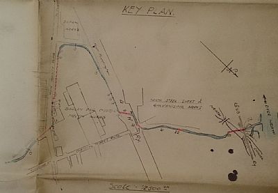
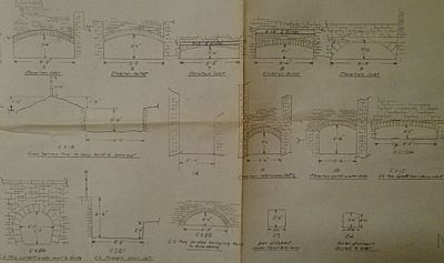
Figure 1 a/b Course of Crythan Brook from Crythan Road to River Neath a) Location of changes of cross-section along course from the Melyn Pond to River Neath outfall b) Examples of typical cross-sections dated 25/11/54
Evaluation of the area of each of the culverts and open spaces that the brook was expected to pass through during the route from Crythan Road to the River Neath is quite revealing. An approximation based on the geometry shown is given in Table 1.
|
Location |
Over Whole Course |
Within Melyn Tin Works |
||
|
Course Type |
Minimum (m2) |
Maximum (m2) |
Minimum (m2) |
Maximum (m2) |
|
Culvert |
0.49 |
2.86 |
1.36 |
2.86 |
|
Open Air |
1.90 |
7.32 |
2.64 |
7.32 |
Table 1 Area (m2) of culverts and open areas along the course of the Crythan Brook from Crythan Road to Neath River circa 1955 at points given in fig.1a
The area of the pipe/culvert under the main road installed circa 1947 was 0.89m2. With a flowrate of approximately 0.132m3/s at a speed of 1m/s during periods of persistent rain only about 15% of the capacity of this culvert would be in use. All culverts within the Melyn Tin Works were above this potential capacity and even the smallest culvert i.e. outfall culvert, 0.49m2 at the River Neath would only be at around 25% of capacity. If all culverts were maintained as designed then it would not be expected there would be significant impact even during periods of heavy rain. However, this did not cater for the extent of blocking by debris etc or extreme weather conditions, a combination of which had continually aggravated the situation since building the canal to the present day. Ironically, at approximately the same time as the date on the plan giving details of the culverts etc yet another major flood occurred (Neath Guardian, 26/11/1954) with Mile End Row impassable again ‘…when Crythan brook overflowed. A retaining wall collapsed and the flood water flowed through houses in Bush Row, flooding them to a depth of several feet.’ Also severely affected were the nearby Neath Tinplate Decorating Works, Eaglesbush Hotel (Inn), and Baglan Engineering Company. The Council had not yet repaired the damaged wall from the previous flood when just two weeks later (Neath Guardian, 10/12/1954) the Crythan brook once more burst its banks with Bush Row being under five-feet of water ‘…at number 23 Bush Row, 73-year-old Jesse Turner, who had a stroke recently, was asleep in the front room when he suddenly awoke and found himself floating…’. The front door of the Turner premises were forced off its hinges and washed away. At the end of 1954 the mayor stated (Neath Guardian, 24/12/1954) that Bush Row should have been demolished many years earlier as they had back-kitchens four or five feet below the road surface, also noting that some houses in Mile End Row were already scheduled for demolition due to continual flooding issues. It was reported (Council Minutes, 1955) that the part of the culvert arch under the Crythan Road had collapsed during early July. It does not appear to have been repaired immediately and would have contributed to the impending disaster. Indeed, all the foregoing floods with their subsequent respective damage and heartache were very soon to be sadly eclipsed.
2. The Great Flood, 18th July 1955
Following a couple of weeks of good weather, a period of extreme rainfall occurred during the afternoon of 18th July 1955. Torrential rain fell between about 2.15-4.15pm, 1” (~25mm) falling between 2.30-2.45pm and at its most intense nearly 3” (~75mm) fell during 2.30-3.30pm. The rain eased by 4.15pm but did not cease until about three hours later. Over 3.5” (~90mm) was recorded at Cimla (Neath Guardian, 29/7/1955). Both the Gnoll and Crythan Brooks massively overflowed. Extensive damage was caused to Neath town centre by the former, but worst hit was Melincrythan which was devastated by the Crythan Brook. When the culvert under the bridge at Crythan Road became blocked and overflowed, the inlet roadside wall of the bridge collapsed under the pressure. With the outlet side of the bridge still walled above road-height the water was turned to run down Crythan Road consequently running down both Exchange Road and Payne Street before continuing onwards via different routes directly into the residential Melin area. Among those most badly affected were Crythan Rd., Exchange Rd., Bowen St., Lombard St., Ethel St., Cecil St., Old Henry St., Alice St., Marshfield Rd. and Southgate St. Local industry again also suffered including the Eaglesbush Foundry (Baglan Engineering) and Tin Plate Decorating Co. Ltd. the latter closing-down for a few days to recover (Western Mail, 19/7/1955). Ironically, Mile End Row did not suffer the worst on this occasion due to the immense volume of water being largely redirected down Crythan Road. A flood appeal fund was established to help those most affected and soon reached over £5400 (*£118,973) (Neath Guardian, 23/9/1955 & 7/10/1955).
2.1 Causes of the Flood
Subsequent investigations revealed the origin of the flood appeared to be when the brook culvert at entry to the old foundry about 100m upstream along Foundry Road, Eaglesbush Valley became overwhelmed due to the combination of the huge volume of water, debris, branches, boulders etc. Eventually the surging water punched its way through a four-feet-thick retaining wall near the blocked inlet culvert to create a six-feet-wide hole. At that time the premises were being used by Neath Council as a paper salvage yard. The result was many tons of paper washed-away along the brook and into neighbouring streets (Neath Guardian, 22/7/1955) which compounded the already dire situation. These initial events are best described in the report by Neath Guardian later that week (Neath Guardian, 22/7/1955) which described events at the old foundry site – ‘My first call was to the Crythan Brook and the family living at the Eaglesbush Foundry. There I interviewed Mr. David Griffiths, who had lived there for 38 years, and his daughter, Mrs. Martha Langford. They were together when the flood waters in all its fury swept down towards the township, taking with it over 50 ton of waste paper stored in a salvage yard at the foundry. They recalled the tearing and crashing of boulders and debris forced down the swollen brook beneath the house, and outside it. They spoke of a three ton lorry being swept down the foundry yard toward the house, and of their thoughts that all was lost. Down at the Crythan Brook bridge a four foot high wall had been leveled by a merciless surge nearly crushing two 14-year-old boys...’
It was also reported (Neath Guardian 21/10/1999) that a Police Sergeant just missed being killed by a large reel of paper that was being washed-away. A series of photographs and related memories of the disaster (refs. Neath Guardian, 22/7/1955 & 21/10/1999) demonstrate the impact of the flood with a further example, fig.2 showing water rushing through the former foundry yard with Foundry House on the left, the course filling the adjacent watercourse shown at the left of the exit.
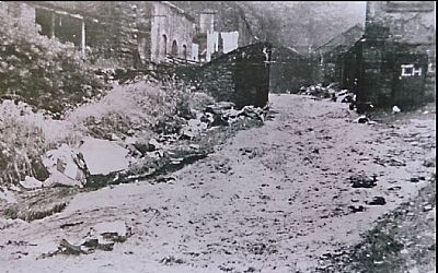
Figure 2 Flood of 1955 - Crythan Brook flowing through the old foundry premises (ref. “Melin Memories”, R. Williams, Bryngold Books, 2010)
As aforementioned, it was stated that following extremely heavy and prolonged rain the Crythan Brook burst through the old foundry buildings. Later, Neath Council acknowledged that there should have been better maintenance of the brook to keep it clear of debris build-up (Western Mail & South Wales News, 27/7/1955) and it was claimed that the Melincrythan area was subject to floods almost yearly, the previous time just six months earlier. The Council had stated that the brook passed-through a number of landowners’ properties and while they had maintained their responsibilities some landowners had not. The obvious call for dramatic remedial measures was made (Neath Guardian, 29/7/1955 & 16/9/1955). A couple of weeks later it was claimed (Neath Guardian, 5/8/1955) that the Crythan and Gnoll Brooks were still choked with debris. A suggestion was made (Neath Guardian, 19/8/1955) to revert to dams upstream to hold-back such spates although their size would have had limited effect under these extreme conditions. There must still have been remnants of these dams upstream as the Council Engineer had recommended not clearing the ponds/dams but to have them totally removed to give the brook a ‘clear run’ (Neath Guardian, 16/9/1955).
While the Borough Engineer’s report (Council Minutes, 1955) stated the whole of the drainage system was outdated, it was added that the most modern sewer/culvert design would not have coped with the deluge even if all brook beds etc. were clear and stressed that the areas of Council responsibility had withstood the flood very well. Work had already been undertaken over the previous few years to mitigate flooding as reported ‘…the Riparian Owners have done a considerable amount of repair work and cleaning out. The depth had been increased by about 2 feet; the [Melyn] pond abandoned and some of the dams removed. The carrying capacity of the culvert under Old Road had been increased 7/8 times. He was trying to persuade the owners to remove all dams. The wall at Gillards Garage had been rebuilt and he understood certain work was being done inside the old Melyn Works.’
Nonetheless, remedial works, including more regular inspections to keep the waterways clear were subsequently undertaken to both the Crythan and Gnoll brooks, both having caused considerable flood damage to Neath.
Since then to within recent years, for various reasons the Crythan Brook has continued to cause flooding. The current scene is one of relative calm with a greater of control of the flow of the brook at its most frequent troublespots coupled with frequent maintenance checks. It is hoped to remain that way.
3. Conclusion
The course of the Crythan Brook between the present Crythan Road and its outfall into the River Neath has been modified extensively since the building of the Melincrythan extension of the Neath Canal circa 1797. Since that time the area between these locations has frequently flooded with a number of mitigating schemes failing to permanently address the problems. Many affected premises built in a low-lying area made them significantly more prone to flooding i.e. Mile End Row, or in the path of the brook when it overflowed i.e. Bush Row. Adequate maintenance and prevention of debris – accidently or deliberately - blocking the many culverts has proven difficult to manage particularly when they were not in the control of the Council, although this has improved.
The statement by the Neath Council Borough Engineer, Mr. Douglas Bailey, following the disastrous flood of 1955 mentioned at the start of this article also contained the following ominous comment (Council Minutes, 1955):
‘It would appear our climate is undergoing a fundamental change, and storms which could be previously considered rare are now occurring with a disturbing frequency.’
He seemed to know.
